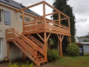
Terrace on stilts
Terrace on stilts in natural DOUGLAS with external access staircase and pergolas.
Home » Survey and Reverse enineering

Cadwork awaits your measurements from your total station and plots your points, lines and surfaces directly in 3D. Precise measurements to the nearest millimetre, for both surveys and layouts.
Land, interior, facade, roof, etc. – everything you see can be implemented in the Cadwork suite, without scaffolding and in complete safety.
Simplify all your measurements with the manual total stations compatible with our modellers.
Couple your device directly or import your data via a USB key and base your design, quantity surveys and production on reliable and extremely accurate measurements. The dynamic mode (direct connection to the PC) provides a simplified real-time display so you can process the data with peace of mind.
Building applications: various measurement points taken by a tacheometer (existing building, slab survey, etc.) are transmitted directly to cadwork 3D. The results are then displayed in real time in the form of points, lines and surfaces in cadwork 3D and cadwork Design.
The 3D laser surveys provide a complete digitisation of the environment using 360° laser measurements ranging from 50cm to 130m with an accuracy of 2mm to 10m in the form of a cloud of points. These measurements are supplemented by an HDR image taken by the scanner, also over 360°, to obtain a colour result and a photo to help with overall understanding.
This technique guarantees unrivalled measurement reliability for your project, with an average overall measurement error of 4mm.
Photogrammetry is based on the assembly of multiple aerial and/or terrestrial photos, with the aim of obtaining a 3D model. Applicable to any scale from a ballpoint pen to the Eiffel Tower, this process produces a faithful reproduction of reality, detailed and in colour, with an accuracy of between 1 and 10cm, depending on the end use.
This technique makes it easier to survey facades or roofs for your estimates: it also enables you to create 3D models for the preparation of urban development, scaffolding or PIC (Plan d’Installation de Chantier).
Test cadwork for 2 months before making your decision! After a 3-day training course, you will receive a free 2-month full trial version, including telephone support and all our services.

Terrace on stilts in natural DOUGLAS with external access staircase and pergolas.
To provide the best experience, we use technologies such as cookies to store and/or access device information. Consent to these technologies will allow us to process data such as browsing behaviour or unique IDs on this site. Failure to consent or withdrawal of consent may adversely affect certain features and functions.